
Issue 4: Bodies and Borders
Behold! The Sun Comes Over the Mountain
Man-made borders are neither seen nor respected by non-human actors.
A meditation on ecosystems as political agents.
In the summer of 2018, I wandered the mountainous border between Idaho and Washington State searching for evidence of the unique qualities that defined each state. Finding tangible similarities between the two states, I proposed to examine the borderlands as a site of connection rather than division during a two-month-long residency at Laboratory in Spokane, Washington. I sought to explore the natural elements of this area that exist outside of man-made divisions: the Spokane River, Old Growth Cedars in Liberty Lake, the sun, wildflowers and mica deposits.
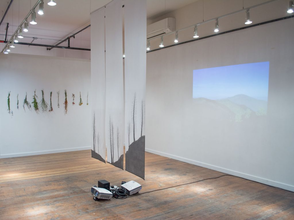
Installation view, Richmond Art Collective, Spokane, WA. Image courtesy of the artist.
”Behold! The sun comes over the mountain,” shown at the Richmond Art Collective, illustrates the capacity of feminist philosophies to provide a reconsideration of human boundaries. Feminist philosophies are not restricted to the roles/thoughts of women, but are opportunities to rethink the dominant representational systems that traditionally have oppressed people, environments, and spaces. Approaching the idea of borders by highlighting what has been excluded from the dominant model stands in contrast to theories based on traditional authority and power. How can we advocate for voices, issues, and concepts that have not had space prior? The exhibition takes the form of large-scale drawings, projected video/sound works and an interactive lighting installation that responds in real time to the intensity of sunlight on either side of the border. Intangible borders, such as state divisions, can be cognitively mapped through aesthetic strategies in order to create openings for fresh perspectives. Through these openings, I carve out space for inclusivity and exchange.

Installation view, Richmond Art Collective, Spokane, WA. Image courtesy of the artist.
We, humans, are part of the natural world and not above or outside it. Jane Bennett articulates a desire for enhanced “receptivity to the impersonal life that surrounds and infuses us, [that this] will generate a more subtle awareness of the complicated web of dissonant connections between bodies, and will enable wiser interventions into that ecology”1. This connectivity to the impersonal non-human elements, or “vibrant materiality” as Bennet calls it, runs alongside and inside humans and points to how an “analysis of political events might change if we gave the force of things more due.” If we can entertain the idea that ecosystems hold political power, especially in the contemporary era of climate change concerns, then we must ascribe non-human elements the role of political actors with a voice and ability to affect change on both global and local scales.

The artist walking the border between Washington and Idaho. Image courtesy of Grace Warnick.
My research into the political power of non-human elements focused on one primary point of reflection: What is the power of man-made borders if they are not respected by non-human actors? To explore this question I went to find evidence of the border. I started in Liberty Lake Regional Park located in Washington State, with its Cedar Grove Conservation Area butted against the state of Idaho. Using Google Maps on my iPhone as a guide I walked the border, one foot in each state, as an attempt to discern tangible differences between sides of an invisible line that is only rendered real through the authoritative structures of maps. Rather than finding any clues to divisions, I became aware of the subtle acts of political resistance by non-human elements: cross-border pollination of wildflowers, streams running from one state to the other dissipating valuable resources, and trees with roots in both states, inherently claiming dual citizenship.

Installation view, Richmond Art Collective, Spokane, WA. Image courtesy of the artist
To fully comprehend the intangibility of the border it is necessary to experience the place of division physically, psychologically and visually to locate myself within the world. Ciaran Benson speaks of the “self” as a locative system that allows us to orient ourselves in relation to space, place, culture and time2. He states that the understanding of our “self” relies on a constant relocation of our body and our ecological relations. We understand ourselves best through our spatial relationships which are reciprocal in nature, constantly re-evaluating themselves in position to each other. This act of relocation allows for an understanding of my position within an ecology of non-human actors and their resistance to the abstract notion of political boundaries.
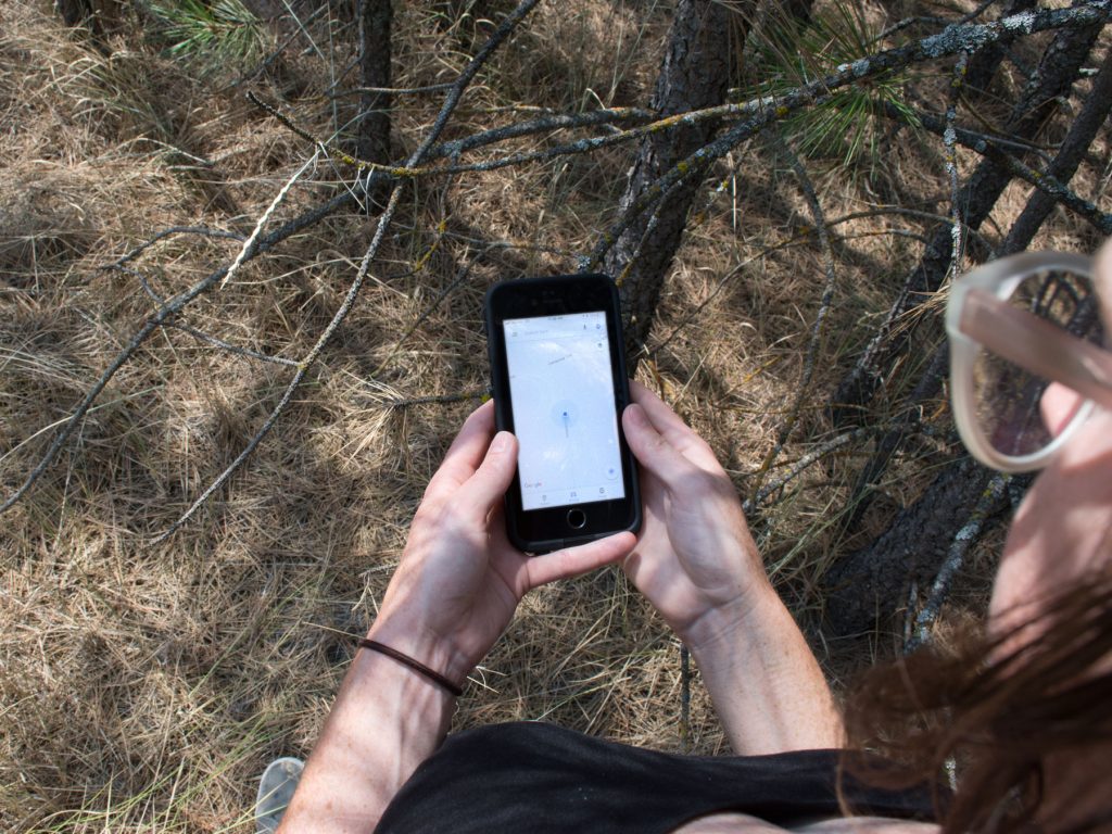
The artist walking the border between Washington and Idaho. Image courtesy of Grace Warnick.
Government-issued maps and Google Maps clearly articulate zones of inclusion and exclusion rather than overlaps or contested areas. Only through the use of Google Maps, rather than state-sanctioned maps was I able to position myself centrally in relation to my environment, were it not for the accurate locative GPS on my iPhone and Google’s ability to orient me to the border I would have been unable to document and mark my environment precisely. Traditionally, cartography and the authority to define boundaries has been reserved for those with political power. Maps have been used throughout time by leaders seeking to define the reach of their power and influence history. By ceding that authority from the state to a privately held company we risk shifting the control of representation to specific individuals who have the ability to alter our visual understanding and orientation of the world. The power of Google Maps lies in its ability to define divisions and support dominant hierarchies of those whose political interests align with their own. Even with the use of an accurate GPS the divisions marked on these maps are intangible and hard to discern physically.
Installation view, Richmond Art Collective, Spokane, WA. Image courtesy of the artist.
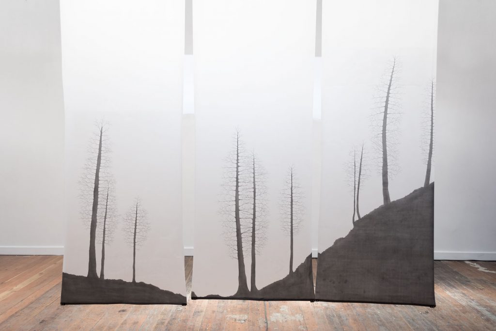
My walks along the border became the foundation for three large-scale graphite drawings of all the trees along a 100 foot stretch with roots in both states. Documenting through photographs, surveying, and personal sketches I constructed a sectional cut of the border’s topology and the dual-citizen trees to serve as a tapestry and dividing line within the gallery space, separating the space into eastern (Idaho) and western (Washington) halves. These three 24 x 108 inch drawings were suspended from the ceiling so that as one walked around the gallery the dividing line would shift and change with the displacement of air and bodies in space.
Through further examination into state-sanctioned documentation of the separation and ownership of non-human resources, I identified two mountain peaks less than ten miles apart on either side of the border. These mountains have more in common than not: they are almost the same elevation (5,243 feet above sea level in Washington and 5,209 feet in Idaho), part of the same mountain range, the Selkirk Mountains, share the same name “Mica Peak,” and thus, are connected through the deposits and geologic formation that is their namesake. The connections between these two were cemented 55 million years ago through continental collisions resulting in metamorphic rock formations extending across the yet to be defined border. What might be gleaned from an understanding of this shared origin, history and resources? How do these mountains continue to relate to each other physically and environmentally? The glittering of mica deposits litters the hike from the base of the mountains to the peaks, speaking of the two mountains’ similar formation. From the top of one Mica Peak you can view the other, though the border is not apparent. At sunset from the Washington State mountain, you can observe the slow enveloping of Mica Peak on the Idaho side in its shadow, as the imprint of one mountain upon the other.
These mountains have long been seen as subservient to humans, their peaks conquered by radio towers and monitoring devices. The effect of humans upon them is heavy-handed and obvious while the mountains’ actions continue to be subtle yet present. Highlighting the mountains’ communication and connection to one another I filmed points of contact between the two peaks. Hiking four and a half miles to the top of Washington State’s Mica Peak I filmed the mountain stretching a slow long shadow over it’s Idaho twin. One mountain mirroring its form on another, as the sun sets. From the other side of the border, I recorded Idaho’s Mica Peak at sunrise with its shadow slowly pulling back to reveal the topography of its Washington-based sister. These films were projected on the East and West sides of the gallery respective to the mountain illustrated, playing alternatingly every ten minutes.
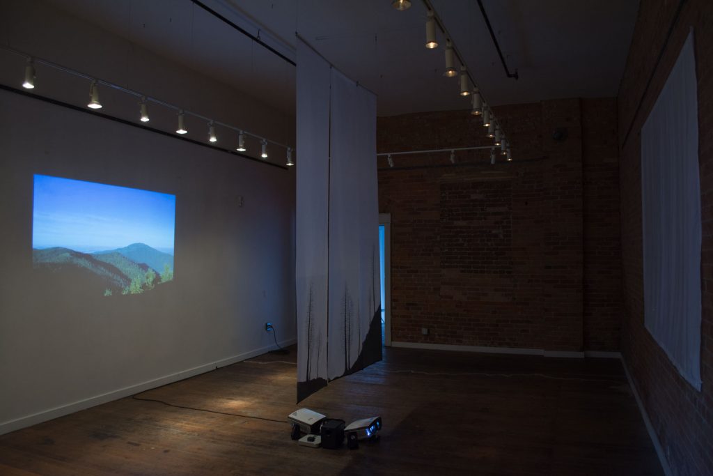
Installation view, Richmond Art Collective, Spokane, WA. Image courtesy of the artist
One of the greatest actors in our ecologically political sphere is the sun, by operating outside the realms of our world it has become one of the most difficult resources to control and define within borders. Our greatest efforts to do so are in the division of the world into distinct time zones. The Oregon Territory was organized in 1848 to include what is presently the states of Oregon, Washington, Idaho as well as parts of Montana and Colorado. As population increased over the next ten years the territory was split into Oregon State and the Washington Territory. From there, Washington gained statehood in 1863, attempting and failing to claim the northern panhandle of Idaho as part of their newly defined limits. This relationship based on shared political, economic and ecological interests extends through history to the current definitions of time zones in the United States. Northern Idaho shares the Pacific Time Zone with Washington State while the southern half of the state, located along the same longitudinal coordinates, is an hour earlier using the Mountain Time Zone. This discrepancy is not a result of geography or science but one formed through the connectivity of Spokane and Coeur D’Alene.
Focusing on the sun as a major aspect of this project I utilized Arduino light sensors and a custom Processing script to document the subtle differences between light qualities on either side of the border. I placed one Light Dependent Resistor (LDR) at Laboratory in Spokane, Washington and another 33 miles away in Coeur D’Alene, Idaho. The LDRs measured the intensity of sunlight in real time sending this information directly to wifi controlled lighting in the gallery. Two tracks of lighting were installed in the space, one on the east side to correspond with Coeur D’Alene, Idaho and the other on the west for Spokane, Washington. More often than not the lighting study illustrated no visible changes between the two locations with minor changes being most apparent at dusk and dawn as the lights dimmed and brightened, highlighting commonalities between the two cities over the divisions.
The aesthetic strategy that Fredric Jameson defines as “cognitive mapping” is an attempt to reveal the spatial and experiential conditions of environments and locative systems3. Jameson believes that cognitive mapping can be used to illustrate the individual experience within the current social conditions, essentially as a political critique. The intangible spaces, such as defined borders, must be mapped through an aesthetic practice in order to be understood. These “maps” are not metaphors but relationships formed between space, time and people. Alternative methods for “mapping” environments can be viewed as the creation of relationships between and across spaces through film, installations, performances and/or interruptions of social environments.
My exhibition became a culmination of mapping techniques across many forms and materialities, in an attempt to share experiences of bodily location, the political power of a place, and time. Any effort to map non-human elements into a consumable, human perspective is inherently flawed and anthropocentric at its core, however, the role of this exhibition was to raise questions of alternative futures rather than realize them. The aforementioned theories of non-human cross-border collaboration manifested in the creation of drawings, projected videos, a mica installation and interactive lighting, collectively experienced as a map of space and Jane Bennett’s concept of vibrant matter.
According to John E. Rees the Shoshoni word “Ee-dah-how,” as it relates to the Inland Northwest region of the Washington-Idaho border, when translated to English, means “Behold! The sun comes over the mountain.”4 This illustrates a relationship between indigenous concepts of space and ecologies as interconnected, while the dominant cultures of the West have made efforts to exclude ecological and indigenous voices in the making of geopolitical divisions. Through a learned awareness of our immersion within a shared human/non-human ecology we can start to view mapping as a locative act, constantly being re-assessed as the web of connections binding us to location shifts and changes. If our location and connections to non-human actors are not fixed, then why do we allow ourselves to be contained by invariable abstract boundaries?
—